Competitor Final Information
14th Aug 2015
There is lots of important information for competitors to read in this ‘Final Information’ message. We would like to reiterate that it is not possible to COMPLETE REGISTRATION AT THE EVENT, UNLESS YOU HAVE photographic ID.
Some important links for further reading:
Salomon Glen Coe Skyline - Race Preview
Ian Corless from TalkUltra reports: ‘The Salomon Glen Coe Skyline™ is just one week away and is arguably one of the most anticipated races in the UK in recent years.’
Salomon Glen Coe Skyline - Recce Report
Shane Ohly and Gary Tompsett report of their completion of the full course earlier this week.
Salomon Glen Coe Skyline – Extended Q&A
The original version of this Q&A was published on the UK’s leading outdoor website UKHillwalking (March 2015), albeit, the Q&A was edited by UKH. We are now publishing the full text and also releasing further details of the safety measures that will be employed during the event.
WHAT YOU NEED TO KNOW – READ ALL THIS
Course Updates
The course has grown a little… We have decided to use a well-established path to descend from the Buachaille Etive Beag col down to a repositioned Checkpoint 5 (reasons for this in the Recce Report. This is shown on the race map. This one change adds over 2km distance to the course. Shane and Gary have now completed a continuous completion of the full race course and with all the zigzagging up and down the various paths, this results in a ground proven distance and height gain of 52.96km / 4,256m.
GPX Download
If you would like a ‘ground proven’ GPX file of both the Full and Bad Weather race routes, they are available HERE. The term Bad Weather is used (by us) to describe gales and/or incessant torrential rain. Light-to-heavy rain is decent-enough weather for us, though we’d really like you too be able to see the amazing views!
Key Timings
Friday 21st August 2015
1800 - Registration Opens
1900 – The Sky’s the Limit Film Showing (25 minutes)
2000 – Salomon Running TV 'Fast and Light' (UK Premiere) followed by Q&A with Salomon athletes Emelie Forsberg and Joe Symonds
2300 - Registration Closes
Saturday 22nd August 2015
0530 - Registration Opens
0615 - Registration Closes
0700 - Race Start
2100 - Course Closes
2000 - Food, drinks and party at Glencoe Mountain Resort
Registration, Photo ID, Kit Check, Trackers etc
It will NOT be possible to register without original photographic ID; a passport, photo driver’s license, national identity card or military ID are all accepted. A bank card is NOT acceptable. You will need to arrive at registration with your running pack packed as all competitors will be subject to a kit check and a GPS tracker will be attached to your bag. It will take about 30 minutes to register - please leave plenty of time if you plan to register on Saturday morning.
Free Films and Q&A
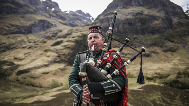
A celebration of running, a celebration of climbing; the Salomon Glen Coe Skyline™ will bring two distinct sports together in a pure celebration of Skyrunning that offers both a tribute and homage to the pioneering days of Marino Giacometti, Bruno Brunod and Fabio Meraldi. To that end, on Friday night before the race, 2 films will be shown: ‘THE SKY’S THE LIMIT’ that provides an insight in to Skyrunning and the yet to be released (Oct 20th), Salomon SRTV episode, ‘FAST and LIGHT’. Followed by a Q&A with Salomon athletes Emelie Forsberg and Joe Symonds. This is free to attend and will be hosted in the Glencoe Mountain Resort bar/café area.
Open Tracking: Follow the Race Live
The Open Tracking GPS trackers can be followed live at:
http://live.glencoeskyline.com
For friends and family following the race please note that there are black spots where tracking data will be temporarily unavailable (see below), and the competitors’ tracker may appear to be stationary. Please don’t worry if this happens as we will be monitoring the competitors’ progress around the course carefully.
Open Tracking: SOS Emergency Button / GPS Trackers
A competitor’s GPS tracker has an SOS Emergency Button. In the event of serious (threat to life or limb) incident, this button should be pressed immediately.
Pressing the SOS button sends a text message with your location to the Race Director via mobile phone signal. In an emergency it is worth attempting an SOS text even if no mobile phone signal is available to call. Pressing this button (until it vibrates) will initiate an emergency response by the emergency services and event staff. An emergency search and rescue helicopter is likely to be requested by the Race Director. Pressing the SOS button leads to automatic disqualification from the event for the person requiring aid.
Please note that although the GPS trackers record their location via GPS satellite signal, they only send out their location data via the phone network (the same network that is used to send text messages). As such, there are black spots along the route where there is no network coverage. At these locations the tracker records its location, buffering the data, and then sends it out once it is back in network coverage. In these black spots it is not possible to send an SOS message but always worth trying.
Race Timing and Safety Monitoring – SPORTident
The race timing is done with SPORTident (SI) dibbers that most competitors will be familiar with. Full instructions can be provided at registration if you have not used the system before. There will be a SI box at each checkpoint and it is the competitor’s responsibility to ensure that they ‘punch’ their SI Dibber into the SI Box at each checkpoint. The SPORTident system will also be sending live information about the competitor’s progress around the course from most of the checkpoints.
Competitors are reminded that failure to ‘punch’ their SI Dibber into the SI Box at each checkpoint will result in an incomplete race time and disqualification.
Curved Ridge and Aonach Eagach
On both Curved Ridge and the Aonach Eagach there will be professional mountaineering instructors to provide advice and assistance to you (if required), including emergency roped assistance for nervous runners in the most difficult sections of the race route – but only deployed as and when required; i.e. then removed. We have always intended to provide this level of safety cover on these sections of the course but holding off on releasing these details until now is a deliberate and considered approach: We did not want to encourage entries from ‘marginal’ competitors who may have – incorrectly – thought that, because of the various safety measures deployed, they would be OK to ‘have a go’. So, please don’t be surprised if you see a friendly mountaineering instructor at these locations.
Our three major concerns on the course and on Curved Ridge and Aonach Eagach in particular are:
Rockfall
Loose rock and stonefall onto competitors is possibly the greatest hazard on the Curved Ridge approach path and higher on the route. We are avoiding ~90% of the possibility of this hazard by routing competitors up a different approach to the start of Curved Ridge. Competitors must follow our waymarking precisely. In the EVENT OF ROCKFALL (or other serious incident) the safety team on Curved Ridge will BLOW A WHISTLE. If competitors hear a whistle on Curved Ridge they should HOLD TIGHT and make themselves SMALL and NOT LOOK UP. Helmets are advisable but not mandatory.
Slip / Fall
There is little we can do to prevent a completely unexpected slip or fall at that precise moment in time. This is where the pre event vetting and competitors experience is most important. That said guidance route marking and coaching of competitors on the crux sections from the mountaineering instructors should reduce the likelihood of that catastrophic fall.
Cragfast
Experiencing a moment of anxiety or fear and becoming ‘cragfast’ is possible even for experienced climbers. Again, the mountaineering instructors positioned on the route will be able to coach competitors through a 'moment'. If all else fails they will be able to provide temporary roped assistance.
Cut offs
There will be a cut off at Checkpoint 10 as competitors cross the A82 before ascending to begin the Aonach Eagach ridge. The cut off time is 15:00 and competitors must have departed Checkpoint 10 by 15:00. This cut off will be based on a desire to have all competitors safely off the higher sections of the course before dark. The cut off will be strictly enforced.
If the bad weather course is requires there will a cut off at Checkpoint 7 as competitors cross the A82 and before ascending to Sron a Choire Odhair-bhig. Checkpoint 7 is 19km (with 1,566m ascent) into the course and the cut off time is 14:00.
There is no guaranteed transport for retiring competitors at these cut off locations and although we will endeavor to transport anyone requiring a lift back to Glencoe Mountain Resort, competitors should be prepared for a long wait and/or walking or hitching back.
Support Points
The will be 15 marshalled support points along the full route. These will be a combination of low-level support points (Checkpoints 1/15 and 10) where food and water will be available to the competitors and high-level support points (Checkpoints 2, 3, 4, 5, 6, 7, 8, 9, 11, 12, 13 & 14) where NO food or water will be available but emergency aid from the event team will be possible.
Family, friends and members of the public are welcome at any of the support points and hot drinks / cold drinks, food etc (at the low-level support points) will be available for competitors and supporters alike.
There will be one portal toilet at the two low-level support points.
Update to Rules
Rule 11 about the use of trekking poles has been updated:
Competitors must NOT use trekking/hiking poles between the start and checkpoint 2, and between checkpoints 11 and 12. This rule will be strictly enforced. Trekking poles are neither advised for or against – it’s up to you.
Mandatory Clothing & Equipment
All competitors must carry or wear the mandatory clothing and equipment. Details HERE.
Spectator Information
Spectators are very welcome; we want to grow the local and outdoor community support for the race to comparable levels to that found at the big European races, in years to come.
Spectating – Low Level
The race HQ, start and finish is at Glencoe Mountain Resort (the ski centre) and any member of the public is very welcome to watch the race start and or finish from this location. There is plenty of car parking, toilets and an excellent cafe/bar.
There are also two low level checkpoints in the Glen Coe valley adjacent to the A82. These are Checkpoints 1/15 and 10. At these locations anyone will be able to see the runners passing through. We are happy to provide a cup of tea or coffee to spectators while they support the runners at checkpoints 1/15 and 10.
At Checkpoint 1/15 there is limited parking in layby and rough ground. Please manouevre with caution at the layby and track/road junction especially.
At Checkpoint 10 we expect some intense interest in the progress of the race. There is limited parking at CP10 and therefore we expect to manage and close this car park quite early. For a more robust parking option, please travel west a futher 1km to the An Torr car park, and then use the good connecting path back to CP10. Under no circumstances, and by request of our partner National Trust for Scotland, are you to park in the passing places of the minor Clachaig Road. Thank You! In fact, the Clachaig Inn (Climber's Bar or Main Bar) is an excellent place to hang out, just 1km walk, until your spectating kicks in! The Clachaig also connects to the An Torr car park via a stunning short walk over a footbridge at the River Coe and with nearby idyllic trails in the Signal Rock woodland.
An Torr Car Park: http://streetmap.co.uk/map.srf?X=212805&Y=756415&A=Y&Z=120
We should also mention that the Kingshouse Hotel (on race route) and Glencoe Visitor Centre + Cafe, 3km west of CP10, have excellent facilities.
Spectating – Guided Walking to Mountain Summits
We will be offering a professionally guided walking group to a high location on the course. This group will leave soon after 0700 (so you can watch the start first) on Saturday morning and head to a high-level destination appropriate to the group’s ability and viewing preferences. The group will be lead by a local mountain guide. The group will return to Glencoe Mountain Resort late afternoon so that the majority of the finishers can be cheered in. As demand is uncertain this year, we are only offering one guide and one walking group, so places are limited. The cost is £10 per person. To book your place, please email [email protected]. Places are allocated on a first come first served basis.
Spectating – Experienced Walkers
You are very welcome on the courses to cheer on the runners. The summit checkpoints are the ideal place to head and these locations will be staffed during the event as and when competitors are expected at them.
Spectating Schedule
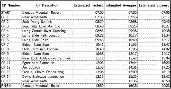
To help plan your spectating, here is an approximate schedule for when we expect runners at the different checkpoints:
Share a lift
Fancy sharing a lift to Glencoe Mountain Resort - just tap in your postcode to find out if there’s anyone else that will be travelling a similar direction to you. Easy! - visit the excellent RaceLifts.org site - please take a minute to register and potentially save quite a bit of cash.
Finally…
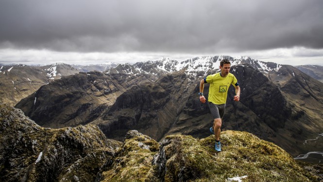
The Salomon Glen Coe Skyline™ is probably the toughest, most inspirational and most challenging mountain running race route in the UK. It has an incredible combination of technical terrain, exposure and remoteness but remains very runable for the most able Skyrunners. We think its an awesome route and we have our fingers crossed for equally awesome weather on Saturday 22nd. See you there!